 SITU Santa Cruz
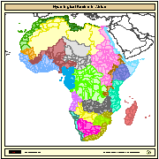
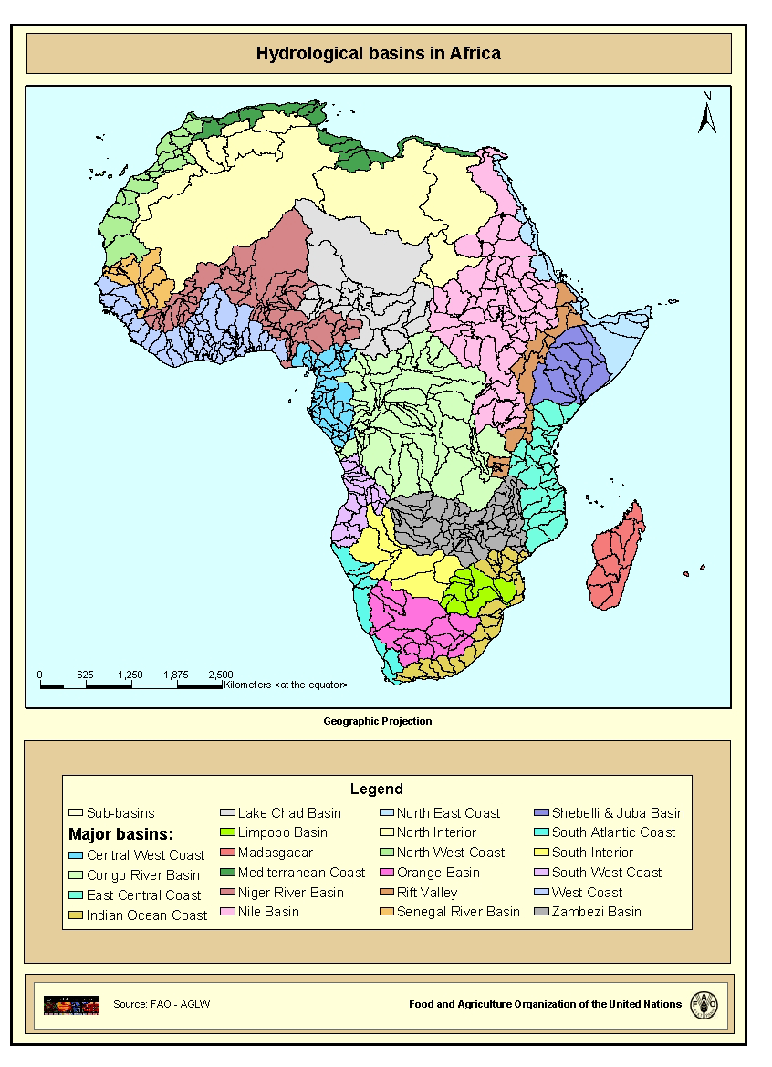
Hydrological Basins in Africa (Sample record, please remove!)
Major hydrological basins and their sub-basins. This dataset divides the African continent according to its hydrological characteristics.
The dataset consists of the following information:- numerical code and name of the major basin (MAJ_BAS and MAJ_NAME); - area of the major basin in square km (MAJ_AREA); - numerical code and name of the sub-basin (SUB_BAS and SUB_NAME); - area of the sub-basin in square km (SUB_AREA); - numerical code of the sub-basin towards which the sub-basin flows (TO_SUBBAS) (the codes -888 and -999 have been assigned respectively to internal sub-basins and to sub-basins draining into the sea)
|
|
. Hydrological Basins in Africa (Sample record, please remove!). https://situ.santacruz.gob.ar:/geonetwork/srv/api/records/da165110-88fd-11da-a88f-000d939bc5d8 |
INSPIRE
Identificación
- Identificador del fichero
- da165110-88fd-11da-a88f-000d939bc5d8 XML
Recurso en línea
- resource_protocol
- WWW:LINK-1.0-http--link
- resource_protocol
- WWW:DOWNLOAD-1.0-http--download
- resource_protocol
- OGC:WMS
Identificador del recurso
- Idioma del metadato
- eng
- Tipo de representación espacial
- Vector
Codificacióin
- Formato
- ShapeFile
- Versión
- Grass Version 6.1
Proyección
- code
- WGS 1984
Classification of data and services
- Categoría temática
-
- Aguas Interiores
Classification of data and services
Coupled resource
Coupled resource
Classification of data and services
Coupled resource
Coupled resource
Palabras clave
Other keywords
- Palabras clave ( Tema )
-
- watersheds
- river basins
- water resources
- hydrology
- AQUASTAT
- AWRD
- Palabras clave ( Lugar )
-
- Africa
Cobertura geográfica
N
S
E
W
))
Temporal reference
Extensión tempora
- Inicio
- 2006-01-01T04:29:00
- Fin
- 2008-01-08T04:29:00
Extensión tempora
- Fecha ( Creación )
- 2000-07-19T14:45:00
Quality and validity
- Linaje
- The linework of the map is obtained by delineating drainage basin boundaries from an hydrologically corrected digital elevation model with a resolution of 1 * 1 km.
- Denominador
- 5000000
Conformidad
Conformidad
Conformidad
Conformidad
Conformidad
Conformidad
Restrictions on access and use
- Limitación de uso
Restrictions on access and use
Responsible organization (s)
Contacto para el recurso
Responsible organization (s)
Contacto para el recurso
Metadata information
Contacto para el metadato
- Nombre de la organización
- FAO - NRCW
- jippe.hoogeveen@fao.org
- Fecha
- 2007-11-06T12:13:00
- Idioma del metadato
- eng
- Codificación
- UTF8